Regional Division of Himalayas


Regional Division of Himalayas
The Himalayan MountainsThe Himalayas are geologically young and structurally fold mountains. They stretch over the Northern borders of India. They form an arc, covering a distance about 2400 km. Their width varies from 400 km in Kashmir to 150 km Arunachal Pradesh, These mountain ranges run in West-East direction from the Indus to the Brahmaputra Rivers. The altitudinal variations in Himalayas are greater in the Eastern half than those in the Western half. The Himalayas consist of three parallel ranges in its longitudinal extent. A number of valleys lie between these ranges.Himadri or Inner Himalayas or Great Himalayas: The Northern most range is known as the Great or Inner Himalayas or the Himadri. It has an average height of 6000 m. It contains all the prominent Himalayan peaks like Mount Everest, Kanchenjunga, Makalu, etc. Kanchenjunga is the highest peak of the Himalayas in India a height of 8598 m. Whereas the highest peak Mount Everest (8848 m) lies in Nepal. Great Himalayas are snow covered all the year round. The core of this part is posed of granite. The fold of Great Himalayas is asymmetrical in nature.Himachal or Lesser Himalayas: This range, lies to the South of the Himadri and forms the most rugged mountain system. It is composed of highly compressed rocks with height varying from 3700 to 4500 m. The average width of this range of the Himalayas is 50 km. It is composed of ranges like Pir Panjal, Dhaula Dhar. The Pir Panjal range is the longest and the most important range. They also contain the valleys having well-known hill stations in areas like Kashmir, Kangra, Kullu (in Himachal Pradesh Mussoorie, Nainital (Uttarakhand), etc.Shiwalik Range: This is the outermost range of the Himalayas with height varying between 900 and 1100 m. The average width is 10 to 50 km. They are composed of coarse sediments brought down by rivers from the main Himalayan ranges. These valleys are covered with thick gravel and alluvium. The longitudinal valleys lying between the Lesser Himalayas and Shiwaliks are known as Duns with names like Dehra Dun, Kotli Dun and Path Dun.
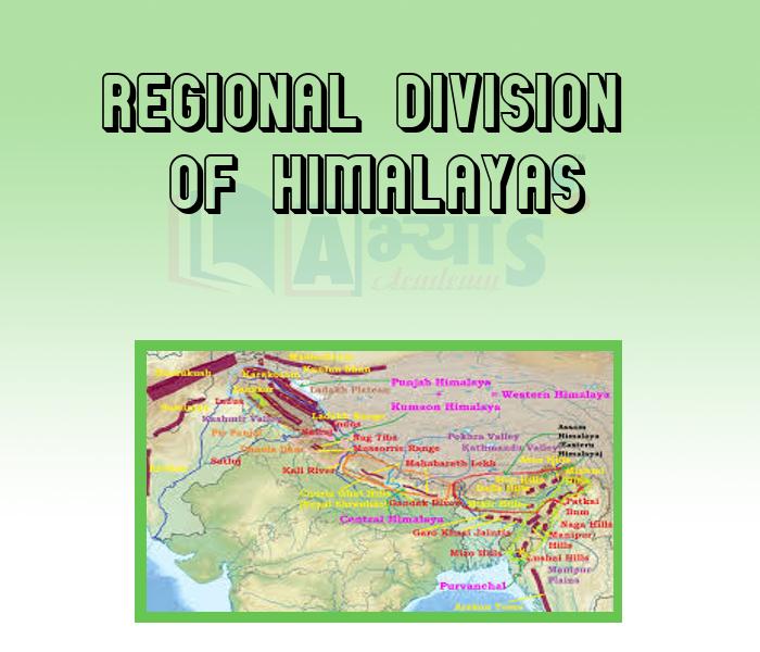
Regional Division of Himalayas: The Himalayas are also divided on the basis of regions from West to East. This demarcation is done by river valleys, i.e. the Indus, Satluj, Kali, Teesta and Dihang rivers, Punjab, Kumaon and Assam Himalayas: In the West, the part of Himalayas lying between Indus and Satluj has been traditionally known as Punjab Himalaya . But it is also known regionally as Kashmir and Himachal Himalaya from West to East, respectively. The part of the Himalayas lying between Satluj and Kali rivers is known as Kumaon Himalayas. The Kali and Teesta rivers demarcate the Nepal Himalayas and the part lying between Teesta and Dihang rivers is known as Assam Himalayas.
In which state is Shiwalik Range situated? | |||
| Right Option : A | |||
| View Explanation |
________ valleys are covered with thick gravel and alluvium.. | |||
| Right Option : A | |||
| View Explanation | |||
Which of the following ranges are mainly composed of highly compressed and altered rocks? | |||
| Right Option : A | |||
| View Explanation | |||
Students / Parents Reviews [20]
Abhyas institute is one of the best coaching institute in the vicinity of Ambala Cantt area. The teachers of the institute are well experienced and very helpful in solving the problems of the students.The good thing of the institute is that it is providing extra classes for the students who are w...

Aman Kumar Shrivastava
10thAbhyas is an institute of high repute. Yogansh has taken admission last year. It creates abilities in child to prepare for competitive exams. Students are motivated by living prizes on basis of performance in Abhyas exams. He is satisfied with institute.

Yogansh Nyasi
7thUsually we see institutes offering objective based learning which usually causes a lag behind in subjective examinations which is the pattern followed by schools. I think it is really a work of planning to make us students grab the advantages of modes of examination, Objective Subjective and Onli...

Anika Saxena
8thOne of the best institutes to develope a child interest in studies.Provides SST and English knowledge also unlike other institutes. Teachers are co operative and friendly online tests andPPT develope practical knowledge also.

Aman Kumar Shrivastava
10thA marvelous experience with Abhyas. I am glad to share that my ward has achieved more than enough at the Ambala ABHYAS centre. Years have passed on and more and more he has gained. May the centre flourish and develop day by day by the grace of God.

Archit Segal
7thAbhyas is good institution and a innovative institute also. It is a good platform of beginners.Due to Abhyas,he has got knoweledge about reasoning and confidence.My son has improved his vocabulary because of Abhyas.Teacher have very friendly atmosphere also.

Manish Kumar
10thWe started with lot of hope that Abhyas will help in better understnding of complex topics of highers classes. we are not disappointed with the progress our child has made after attending Abhyas. Though need to mention that we expected a lot more. On a scale of 1-10, we would give may be 7.

Manya
8thThe experience was nice. I studied here for three years and saw a tremendous change in myself. I started liking subjects like English and SST which earlier I ran from. Extra knowledge gave me confidence to overcome competitive exams. One of the best institutes for secondary education.

Aman Kumar Shrivastava
10thAbhyas academy is great place to learn. I have learnt a lot here they have finished my fear of not answering.It has created a habit of self studying in me.The teachers here are very supportive and helpful. Earlier my maths and science was good but now it has been much better than before.

Barkha Arora
10thWhen I have not joined Abhyas Academy, my skills of solving maths problems were not clear. But, after joining it, my skills have been developed and my concepts of science and SST are very well. I also came to know about other subjects such as vedic maths and reasoning.

Sharandeep Singh
7thMy experience with Abhyas Academy has been very good. When I was not in Abhyas whenever teacher ask questions I could not speak it confidently but when I came in Abhyas, my speaking skills developed and now I am the first one to give the answer of teachers question.

Upmanyu Sharma
7thAbhyas institute is one of the best coaching institute in the vicinity of Ambala cantt.The institute provides good and quality education to the students.The teachers are well experienced and are very helpful in solving the problems. The major advantages of the institute is extra classes for weak...

Shreya Shrivastava
8thAbhyas is a complete education Institute. Here extreme care is taken by teacher with the help of regular exam. Extra classes also conducted by the institute, if the student is weak.

Om Umang
10thMy experience with Abhyas is very good. I have learnt many things here like vedic maths and reasoning also. Teachers here first take our doubts and then there are assignments to verify our weak points.

Shivam Rana
7thI have spent a wonderful time in Abhyas academy. It has made my reasoning more apt, English more stronger and Maths an interesting subject for me. It has given me a habbit of self studying

Yatharthi Sharma
10thIt was good as the experience because as we had come here we had been improved in a such envirnment created here.Extra is taught which is beneficial for future.

Eshan Arora
8thIt has a great methodology. Students here can get analysis to their test quickly.We can learn easily through PPTs and the testing methods are good. We know that where we have to practice

Barkha Arora
10thMy experience with Abhyas academy is very nice or it can be said wonderful. I have been studying here from seven class. I have been completing my journey of three years. I am tinking that I should join Abhyas Academy in tenth class as I am seeing much improvement in Maths and English

Hridey Preet
9thAbhyas Methodology is very good. It is based on according to student and each child manages accordingly to its properly. Methodology has improved the abilities of students to shine them in future.

Manish Kumar
10thBeing a parent, I saw my daughter improvement in her studies by seeing a good result in all day to day compititive exam TMO, NSO, IEO etc and as well as studies. I have got a fruitful result from my daughter.